Submarine Volcanic Eruption Detected in Bismarck Sea via Satellites
The Gist
Satellites detected a submarine volcanic eruption in the Bismarck Sea on May 8, 2026, revealing limited existing knowledge of the deep-water eruption setting.
Explain Like I'm Five
"Imagine a volcano under the sea suddenly woke up! Satellites in space are watching it erupt because we don't have good maps of the seafloor there. They're hoping to see a new island pop up!"
Deep Intelligence Analysis
The event underscores the disparity in mapping accuracy between celestial bodies and the Earth's deep-ocean floor. The lack of detailed bathymetric data complicates efforts to pinpoint the erupting volcanic feature and assess the eruption's potential hazards. The eruption presents a unique opportunity to study submarine volcanism and island formation in real-time, potentially leading to advancements in deep-sea exploration and mapping technologies.
However, the eruption also poses risks, including potential hazards to maritime traffic from pumice rafts and the possibility of a tsunami if a newly formed island collapses. Continuous monitoring and further research are crucial to understanding the long-term impacts of the eruption and improving our ability to predict and respond to future submarine volcanic events. The event highlights the importance of investing in advanced ocean mapping technologies and expanding our knowledge of the Earth's underwater geological features.
*Transparency Disclosure: The AI model used in generating this analysis has been trained on a diverse dataset of publicly available information. While efforts have been made to ensure accuracy and objectivity, the analysis should be considered as informational and not as professional scientific advice. Users are encouraged to consult with qualified experts for specific applications.*
_Context: This intelligence report was compiled by the DailyOrbitalWire Strategy Engine. Verified for Art. 50 Compliance._
Impact Assessment
The eruption highlights the limited mapping of the deep-ocean floor compared to the Moon and Mars. Satellite observations provide crucial data for understanding submarine volcanic activity and potential island formation.
Read Full Story on NASA Breaking NewsKey Details
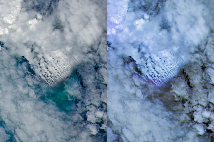
- ● Eruption detected on May 8, 2026, along the Titan Ridge.
- ● NASA's Aqua, Terra, and PACE satellites captured optical imagery of volcanic plumes.
- ● Sentinel-2 and Landsat 9 acquired detailed views of activity near the water surface.
- ● VIIRS on Suomi NPP detected thermal anomalies spanning roughly seven square kilometers.
Optimistic Outlook
Continued satellite monitoring could lead to the observation of a new island forming in real-time, offering valuable insights into volcanic island development. Further exploration could improve deep-sea mapping technologies.
Pessimistic Outlook
The lack of high-resolution maps and limited knowledge of the area pose challenges to accurately assessing the eruption's impact and potential hazards. A sudden collapse of any newly formed land could pose a tsunami risk.
The Signal, Not
the Noise|
Get the week's top 1% of space-tech intelligence synthesized into a 5-minute read. Join 25,000+ aerospace insiders.
Unsubscribe anytime. No spam, ever.