Von Kármán Vortices Observed Near Remote Peter I Island
The Gist
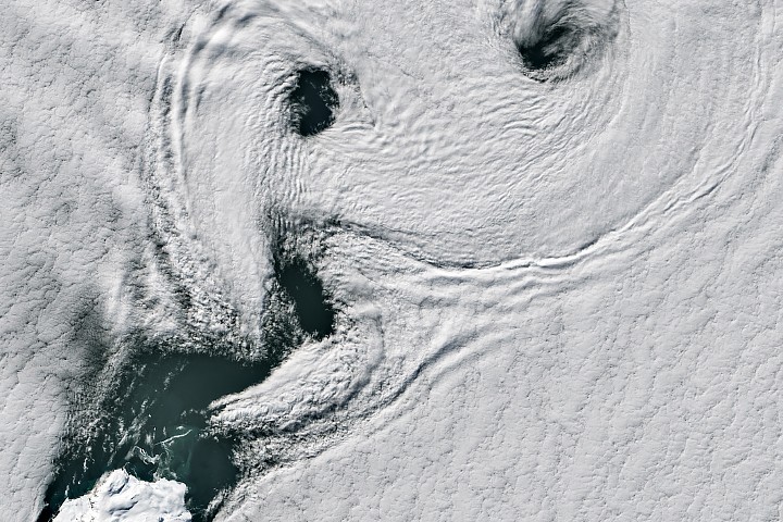
Landsat 8 captured von Kármán vortex streets near Peter I Island in the Bellingshausen Sea.
Explain Like I'm Five
"Imagine throwing a small rock in a stream; the water makes swirls behind it. Peter I Island is like that rock, and the wind makes swirls of clouds behind it that a satellite can see!"
Deep Intelligence Analysis
NASA's Operation IceBridge campaign in 2011 underscores the importance of airborne science missions in bridging observational gaps between satellite missions. The data collected during these campaigns, along with satellite imagery, contributes to a more comprehensive understanding of Earth's polar ice and climate variability. The limited scientific research conducted on Peter I Island due to its remoteness emphasizes the need for innovative approaches to data collection and analysis in such regions.
Further studies of the island's geology, biodiversity, and ice core data promise to yield valuable insights into past climate conditions and the impact of environmental changes on remote ecosystems. The challenges associated with accessing and studying Peter I Island also highlight the importance of international collaboration and technological advancements in advancing scientific knowledge in extreme environments. Understanding these atmospheric phenomena is crucial for accurate weather modeling and satellite observation, especially in data-sparse regions like the Southern Ocean.
_Context: This intelligence report was compiled by the DailyOrbitalWire Strategy Engine. Verified for Art. 50 Compliance._
Impact Assessment
Understanding atmospheric phenomena like von Kármán vortices is crucial for weather modeling and satellite observation accuracy, especially in remote regions. Studying Peter I Island provides insights into climate history and biodiversity in a challenging environment.
Read Full Story on NASA Breaking NewsKey Details
- ● Peter I Island is a remote, ice-cloaked volcano located 400 km off West Antarctica.
- ● Von Kármán vortex streets form when winds (18-54 km/h) are disrupted by obstacles.
- ● The island's summit features a 100-meter-wide circular crater at 1,640 meters above sea level.
- ● NASA surveyed the island during a 2011 Operation IceBridge campaign.
Optimistic Outlook
Continued satellite observation and airborne missions like IceBridge will enhance our understanding of polar climate dynamics. Further research on Peter I Island's ice core data could reveal valuable insights into past climate variability.
Pessimistic Outlook
The remoteness and challenging ice conditions surrounding Peter I Island limit scientific research. Stronger gales can disrupt vortex formation, hindering observation and data collection efforts.
The Signal, Not
the Noise|
Get the week's top 1% of space-tech intelligence synthesized into a 5-minute read. Join 25,000+ aerospace insiders.
Unsubscribe anytime. No spam, ever.