AI Enhances Martian Temperature Maps for ISRU
The Gist
AI-driven data fusion sharpens Martian thermal inertia maps, improving ISRU resource identification.
Explain Like I'm Five
"Imagine using a super-smart computer to make blurry Mars temperature maps super clear, so we can find water and rocks to build a Mars base!"
Deep Intelligence Analysis
_Context: This intelligence report was compiled by the DailyOrbitalWire Strategy Engine. Verified for Art. 50 Compliance._
Impact Assessment
Improved thermal maps enable better identification of resources for in-situ resource utilization (ISRU) on Mars, crucial for establishing a sustainable Martian base.
Read Full Story on Universe TodayKey Details
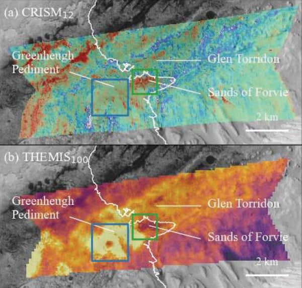
- ● Data fusion combines THEMIS (100m/pixel) and CRISM (12m/pixel) data.
- ● An 'Extra Tree Regressor' machine learning model identifies relationships between visual and thermal data.
- ● Thermal inertia (TI) mapping reveals grain size, rock abundance, and potential water ice locations.
Optimistic Outlook
Higher resolution thermal maps could accelerate ISRU development, reducing reliance on Earth-based resources and enabling more ambitious Martian missions.
Pessimistic Outlook
The reliance on older instruments (THEMIS, CRISM) may limit the accuracy and scope of the enhanced maps, requiring further validation with on-site data.
The Signal, Not
the Noise|
Get the week's top 1% of space-tech intelligence synthesized into a 5-minute read. Join 25,000+ aerospace insiders.
Unsubscribe anytime. No spam, ever.