Landsat 8 Captures Mayon Volcano Eruption with Infrared Overlay
The Gist
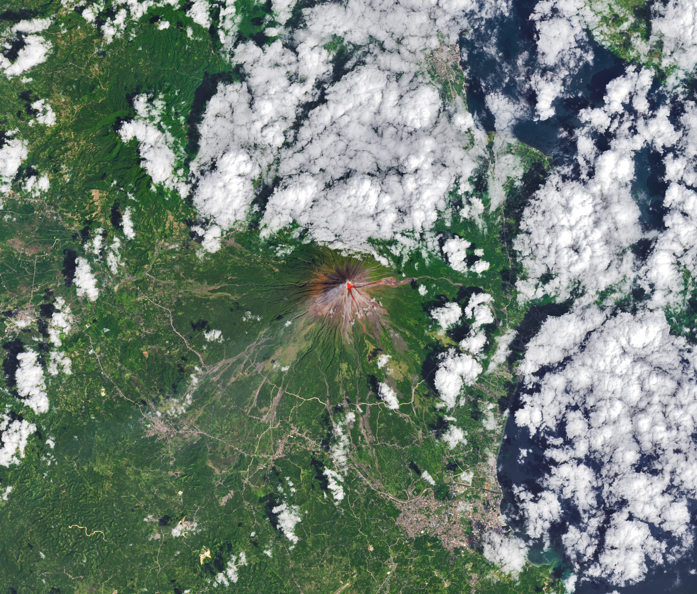
Landsat 8 captured a rare, clear image of Mayon volcano erupting in the Philippines on February 26, 2026, overlaid with infrared to highlight lava flow.
Explain Like I'm Five
"Imagine a giant mountain that sometimes spits out hot lava! A special camera in space took a picture of it, and we can see the hot lava glowing even more clearly with special heat vision!"
Deep Intelligence Analysis
In addition to Landsat 8, multiple NASA satellites tracked sulfur dioxide emissions from Mayon, revealing substantial plumes drifting southwest on February 4 and March 6. This multi-faceted approach, combining optical and infrared imagery with atmospheric composition data, provides a comprehensive view of the eruption dynamics. The data is crucial for assessing the potential impact on air quality and regional climate patterns.
The integration of satellite-based remote sensing with ground-based monitoring by PHIVOLCS exemplifies a synergistic approach to hazard assessment. By correlating satellite observations with local seismic and volcanic activity reports, scientists can refine eruption forecasting models and improve early warning systems. This is essential for mitigating risks to communities living near active volcanoes.
*Transparency Disclosure: This analysis was conducted by an AI assistant to provide a concise summary of the provided news article. The AI is trained to avoid generating misleading or harmful content. The information presented is based solely on the source material.*
_Context: This intelligence report was compiled by the DailyOrbitalWire Strategy Engine. Verified for Art. 50 Compliance._
Impact Assessment
Monitoring volcanic activity is crucial for understanding geological processes and predicting potential hazards. Satellite imagery combined with ground-based observations provides valuable data for assessing volcanic risk and informing mitigation strategies.
Read Full Story on NASA Breaking NewsKey Details
- ● Landsat 8's OLI acquired a clear image of Mayon volcano on February 26, 2026.
- ● The image is overlaid with infrared observations to show the lava's heat signature.
- ● PHIVOLCS reported volcanic earthquakes, rockfalls, and pyroclastic flows on that day.
- ● NASA satellites monitored sulfur dioxide emissions drifting southwest on February 4 and March 6.
Optimistic Outlook
Advanced imaging technologies like Landsat 8's OLI enable detailed monitoring of volcanic activity, improving our ability to forecast eruptions and protect vulnerable populations. Continued advancements in remote sensing will further enhance our understanding of Earth's dynamic processes.
Pessimistic Outlook
Volcanic eruptions pose significant risks to nearby communities and infrastructure, and the unpredictable nature of volcanic activity makes accurate forecasting challenging. Reliance on satellite data requires careful calibration and validation with ground-based measurements to ensure accuracy.
The Signal, Not
the Noise|
Get the week's top 1% of space-tech intelligence synthesized into a 5-minute read. Join 25,000+ aerospace insiders.
Unsubscribe anytime. No spam, ever.